This guidance outlines the required criteria and provides general advice for the preparation of new deed plans.
For registration, we need to be able to delineate your plot and any related registrable rights or encumbrances on the cadastral map. If your deed doesn’t sufficiently describe these for mapping, you’ll need to prepare a plan to clarify their boundaries.
Here you'll find advice and the required criteria for creating your deed plans, with example images. This guidance also includes examples of plans that do not meet the criteria.
If plans and deeds accompanying a land register application don’t satisfy our requirements, the application must be rejected under the one-shot rule.
Introduction
The Land Registration etc. (Scotland) Act 2012 (the Act) formally introduced the cadastral map as an integral part of the land register. The land register is a public register of rights in land in Scotland, which includes the seabed of the territorial sea of the United Kingdom adjacent to Scotland.
The Act places a statutory obligation on the keeper to make up and maintain the cadastral map. The cadastral map is comprised of individual cadastral units, and each cadastral unit represents a single registered plot of land. Sections 11, 12 and 13 of the Act set out the general provisions for the cadastral map, which state that the cadastral map must show the totality of registered geospatial data, other than data that is classed as supplementary to individual title sheets.
The Act sets out general application conditions and conditions of registration applicable to each application type. These conditions place a duty on the applicant to ensure that the deed sufficiently describes the plot to enable the keeper to delineate the boundaries of the plot on the cadastral map. Further to this, where a registrable encumbrance affects only part of the plot, the deed must sufficiently describe or identify the lesser area on a plan to enable the boundaries of that area to be delineated on the cadastral map. The requirement may be met by reference to an earlier deed which contains a full description and/or plan which is sufficient to identify the relevant area.
Where the description or plan of a plot does not satisfy the keeper's requirements the application for registration must be rejected.
This guide has been created to explain the keeper's requirements for any newly prepared plans to ensure that they are acceptable for the purposes of registration. It provides examples of best practice to be adopted when preparing plans for registration. Annex A contains examples of plans which do not meet the keeper's requirements for registration.
The purpose of the land register is to register rights in land in Scotland. Transfer of title from the sasine register to the land register often means that we are reliant on plans and descriptions used in historical, prior title deeds. The quality of the description or plans to these deeds is not always sufficient for registration purposes. A plan may be required to clarify the historical descriptions contained in such deeds.
Advice for preparation of plans
The following paragraphs provide advice and preferred criteria for the preparation of new deed plans, plans to accompany an advance notice over part of a registered plot or plans being submitted as part of the development plan approval (DPA) process. A newly prepared plan which does not meet the essential criterion, that it enables the keeper to delineate the boundaries of the plot or part of the plot on the cadastral map, will not be acceptable for registration purposes.
The following guidance is not mandatory, however it is strongly recommended that it is borne in mind when preparing a new plan for use in any of the registers under the control and maintenance of the keeper.
A deficiency in a plan annexed to a deed presented for recording in the sasine register may have adverse consequences when that property is later transferred to the land register.
Application to transfer an unregistered plot
To determine if a new deed plan is required you should consider whether the description of the plot as detailed in prior title deeds, including associated plans, is sufficient to enable the keeper to identify and delineate the boundaries of the plot and any registrable rights or encumbrances relating to the plot, on the cadastral map in terms of section 23(1)(c) and (d).
Deeds relating to seabed plots
The Act clarifies that the territorial seabed adjacent to Scotland is registrable in the land register. To enable registration of rights in the sea to be mapped the keeper has specific requirements in relation to the description and the plan of the plot being registered.
Deeds relating to registered plots
Where the deed being registered relates to the whole of a registered plot, that is the entirety of an existing land register title is being transferred, generally there will be no requirement to provide a plan to the transfer deed as the extent of the plot will already be delineated on the cadastral map. However, where the deed also seeks to register new rights or encumbrances that require to be reflected on the cadastral map a new plan would be required, for example disposition incorporating a new grant of servitude.
Deeds relating to part of a registered plot
Where the deed relates to only part of a registered plot of land or the subjects of a lease, the boundaries of the part will require to be reflected on the cadastral map, the description of the part should be sufficient to enable the keeper to comply with the requirements of the Act. Generally, a plan should be prepared to enable the boundaries of the part to be delineated on the cadastral map, or alternatively the plot may be described by reference to an approved development plan, authorised as part of the keeper's development plan approval (DPA) scheme.
In the absence of a clear and definable description, plan or reference to an approved DPA plot number, the keeper will be unable to identify the plot or that part of the plot being conveyed. The application to register the deed would therefore fail as the keeper could not comply with the duties laid out in section 26(1)(d) of the Act, that is delineation of the boundaries of the part being transferred.
Essential criteria for plans
The plan must sufficiently define the plot(s) being registered, to enable the keeper to delineate the boundaries of the plot on the cadastral map.
Where the deed relates to part only of a registered plot, the part must be sufficiently defined on a plan to enable the boundaries of the part to be delineated on the cadastral map.
Where registrable rights or encumbrances require to be defined on a new plan, these should be presented sufficiently to enable, where appropriate, delineation on the cadastral map.
As the Ordnance Map is the base map for the cadastral map it is recommended that all new plans are produced at a scale appropriate to the Ordnance Map survey scale for the area being registered.
Newly prepared plans should show the following:
- scale and orientation of the plan
- sufficient surrounding detail to enable the location and position of the plot to be fixed
- clearly define the boundaries of the plot, preferably with measurements. Where measurements are reflected on a newly prepared plan these should be expressed in metric units
All references shown on the deed plan must be clearly defined and identifiable. Where the plot of land is comprised of seabed, the plan must be accompanied by a description of the plot using OSGB36 coordinates and a location plan showing the plot of land in relation to the coast of Scotland.
Scale, orientation and surrounding detail
- The scale and compass orientation of north must be shown on the plan. A drawn or bar scale is also desirable as this allows any distortion by copying to be identified.
- The plan must contain sufficient surrounding detail to enable the location and position of the plot to be fixed with accuracy eg fences, neighbouring buildings, road junctions, street names and numbers.
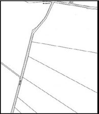
In the example below (fig 1), although the orientation and scale can be determined from the plan, it is not possible to identify exactly which plot of land the plan relates to. The deed plan could potentially relate to any of the plots coloured on the cadastral map (fig 2). Essentially the plan is a floating shape as the location cannot be determined. An adequate deed plan must contain sufficient surrounding detail to enable the plot to be accurately located and fixed.


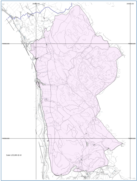
The plan in fig 3 below provides the orientation of the plan and sufficient surrounding detail to enable the exact location of the plot to be identified on the cadastral map. From the detail provided the keeper can clearly establish that the plot is the area shown coloured pink on the cadastral map (fig 4).

Cadastral map fig 4
As the OS map is the base map for the cadastral map, the location of the plot will determine the scale of the underlying map detail in use. This will be at a scale of 1:1,250, 1:2,500 or 1:10,000 for plots falling within urban, rural or mountain/moorland areas respectively. Excerpts of the OS Map at these three scales are shown in the images below, Map figs 5, 6 & 7.
When preparing a new deed plan, consideration should be given to the location and scale of the underlying area of map used and determined by the location of the plot.
Map fig 5 - 1: 1,250

Map fig 6 - 1: 2,500

Map fig 7 - 1: 10,000

Scale, orientation and surrounding detail - other considerations
If the scale of the plan being used is insufficient to reflect the necessary detail, use of an inset plan at a larger, more detailed scale, may be appropriate to identify and provide detail for small areas such as bin stores or encumbrances. Invariably, a plan at 1:1,250 scale cannot provide sufficient detail, therefore a plan at a larger scale may be required to enable the relevant detail to be reflected on the cadastral map.

The plan above (fig 8) depicts a row of bin stores that would not normally be reflected on the underlying OS base map, however as an area of land in exclusive or shared ownership, the bin stores will generally require to be delineated on the cadastral map. The scale and detail of the deed plan or inset plan should be sufficient to enable the keeper to reproduce the extent of the bin stores.
Scale, orientation and surrounding detail - potential issues
Landranger map
The plan below (fig 9) has been produced using the Ordnance Survey Landranger series of maps, which are all purpose maps produced at a scale of 1:50000. However, the scale of map used by the keeper for the same area is 1:10,000 (fig 10).
Plans submitted using 1:50000


The 1:10000 base map shows significantly more detail than that shown on the Landranger map. As a result it is not possible to clearly identify from the Landranger map the boundaries of the plot to be delineated on the cadastral map.
In this instance a new plan at the appropriate scale preferably, at maximum, a scale of 1:10,000, identifying the location and clearly defining the boundaries of the plot should be prepared.
Raster maps
Raster map products may be available for use at the same scale as the underlying OS map detail being used by the keeper. However, care must be taken when using these products as the basis for a new deed plan. Rationalisation of the detail on raster maps may conflict with the more detailed feature representation available on Mastermap, this could impact significantly when registering a plot and may lead to the application being rejected as the conditions of registration cannot be met.


Large scale plans
The plan in fig 13 is acceptable for registration; although there is no north point (orientation), the scale of the plan is noted, the boundaries of the plot are clearly defined and the location of the plot can be fixed on the cadastral map by and in relation to the surrounding features and detail supplied.

The plan has been produced at a large scale and shows a small gap between the south east boundary of the plot and an existing feature depicted on the Ordnance map. Due to the tolerances of the underlying base map a gap of this size would not be reflected on the cadastral map.
A plan submitted at a large scale may show detail, such as juts which fall outwith the OS capture criteria for the scale of map used by the keeper. The plan in fig 14 shows that the fences to the front and rear of the gable wall between Nos.66 and 68 do not project in a straight line from the gable wall; they lie slightly to the east of the wall. Small juts of this nature are not shown on the base map, the fence, where shown, will be shown as a projection of the gable wall as shown on the base map in fig 15. Generally the subjects will be registered following the boundaries depicted on the base map.

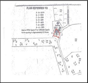
The deed plan at fig 16 below depicts small juts on the frontage of the building. Juts of this nature fall outwith current Ordnance Survey data capture tolerance (fig.17 - base map) and generally will not be plotted on the cadastral map.


The plan in fig. 16 above is an old plan, the scale of which is reflected in imperial measurements, ie 1 inch to 6 feet. New plans must reflect the scale in metric units of measurement.
Boundaries, measurements and references
To enable the keeper to delineate the boundaries of the plot and any rights or encumbrances that affect the plot on the cadastral map:
- the plan must clearly define and indicate the boundaries of the plot, using a suitable graphic reference, for example coloured edging, tinting or hatching
- exclusive and shared areas must be clearly differentiated and referenced; references provided must be consistent with the text of the deed
- where an encumbrance affects part of a plot, this must be clearly defined on the plan to enable the extent of the area affected to be reflected on the cadastral map.
Where appropriate the following criteria also apply:
- Historic title deeds often state that the plans annexed to a deed are demonstrative only and not taxative - this is not acceptable for new plans.
- Where dimensions or measurements are reflected on a new plan, these must be in metric units and shown to one decimal place.
- Where dimensions are provided on a plan, these must agree with the scaled measurements.
- Where buildings, pathways, roads, etc are referenced on the plan to reflect shared or common rights, they must be shown in the correct position relative to other surrounding detail. The detail reflected must be clearly defined and unambiguous, with a clear start and end point; references should not simply run off the page.
Unclear boundary extent
In the example at fig 18, the right of access coloured blue on the plan runs off the page, the end point of the access road has not been identified. As the boundaries of the area cannot be ascertained and identified with certainty, it cannot be delineated on the cadastral map, a condition of registration cannot been met.


The full extent of the access road is the area tinted blue and brown on the fig 19; however the keeper cannot make that interpretation: the onus is on the applicant to provide appropriate information.
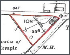
The graphic reference used to illustrate the plot on this plan (fig 20) has been hand drawn with a red pen. It is not possible to ascertain on the base map (fig 21) which feature the south west boundary of the plot should follow, neither it is possible to accurately identify the position of the legal boundary in front of the cottages.
Undefined boundaries
Undefined boundaries (i.e. where no physical boundary exists) must be accurately fixed to existing detail by metric measurements shown on the plan.
The property shown as Plot 3 on the plan in fig 22 has been identified as property No.7 on the Ordnance Map. The Ordnance Map (fig 23) does not show a feature between No.7 and its neighbour to the north, No.9. The plan has accurately fixed the undefined boundary, using dimensions, in relation to the existing south boundary. It has specified that the undefined boundary is 39.4m from the south boundary at its west-most point and 41m at its east-most point. This plan allows the keeper to accurately fix the position of the plot to be registered.

Dimensions
A plan employing dimensions which are simply a perimeter measurement and that are incapable of being accurately plotted or proven are unacceptable.
Dimensioned plans should include proof measurements which may consist of:
- cross/diagonals
- angles at each change of boundary direction
- local or National Grid co-ordinates of boundary changes supported by appropriately measured and defined dimensions that accord with the co-ordinate details
- any other form of independent check which is capable of proofing the survey
Plot is comprised wholly of seabed or rights in the sea
Where the application relates to a plot of land comprising seabed or rights in the sea, eg salmon fishing rights or moorings, a plan defining the boundaries of the plot will be required. The plan must enable the plot to be delineated on the cadastral map and should identify the location of the plot in relation to the coast of Scotland, where applicable, and this may be in the form of a separate inset or location plan.
Where the plot or right to be registered falls wholly within the sea or tidal waters the deed must include a description of the plot using OSGB36 - British National Grid (ESPG:27700) projected coordinate system. No other coordinate referencing system is acceptable for registration purposes.
The coordinates of the plot should preferably be presented in a table format annexed to the deed, see fig 24 below. The coordinates will be incorporated as supplementary data to the title sheet, in the form of a schedule.
| OSGB36 coordinates | Easting | Northing |
|---|---|---|
| 397417.6271 | 804519.834 | |
| 396566.2001 | 804530.8 | |
| 396564.2001 | 804534.85 | |
| 396561.1001 | 804541.2 | |
| 396558.1501 | 804547.65 | |
| 396555.3001 | 804554.15 | |
| 396554.9501 | 804554.85 | |
| 396552.7501 | 804560.2 | |
| … | … |
Plot is comprised of seabed and other land
Where the plot is comprised of both seabed and land not covered by water, a plan reflecting the boundaries of the plot will be required and the general deed plan criteria guidelines can be applied.
Where the plot straddles land and sea the coordinates of the plot need not be described by reference to OSGB36 coordinates, but sufficient surrounding detail must be supplied to enable the plot to be fixed and delineated on the cadastral map. However, where the relevant coordinates are supplied these will be incorporated into the title sheet.
Ancillary useful information
Details of how, by whom, and when the survey was completed may be useful to the keeper. Information as to the currency of the survey detail and whether or not it relates to the as built positions or merely the proposed layout should be provided.
Digital data
Read detailed guidance on using digital data
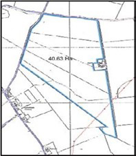
For registration purposes, a deed must sufficiently describe the plot to enable the keeper to delineate the boundaries of that plot on the cadastral map. However, the data reflected on a traditional paper plan may be accompanied by digital data. For the majority of land register applications digital data is not required. However, for applications that cover a large area of ground or contain complex plotting, use of digital data is beneficial.
Submission of digital plans (GIS and CAD data) - formats
Registers of Scotland can accept digital plans containing GIS (Geographical Information System) and CAD (Computer-Aided Design) data in the majority of industry standard formats. Our preferred data format is ESRI.shp.
When providing digital data the software name and version used to create it should be supplied. The data should be presented using co-ordinate reference system: British National Grid (EPSG:27700).
The Ordnance Survey map
Registers of Scotland currently use Ordnance Survey's Mastermap Topographic Layer as the base map for the cadastral map. The large-scale mapping layer provides a highly detailed view of Scotland's landscape including individual buildings, roads and areas of land.
Ordnance Survey data is subject to Crown Copyright and reproduction in whole or in part is prohibited without the prior written permission of Ordnance Survey.
Plans reports service
The keeper provides a pre-registration plans report service. This will identify if the plan is suitable for registration purposes and also compares the boundaries of the plot against the base map to establish if they correspond with the physical features defined on the Ordnance Survey map.
Find out more about our plans reports.
Plans that do not meet the criteria
This section highlights some of the common errors that Registers of Scotland (RoS) encounters with plans; these may be plans annexed to historic or old sasine deeds or new plans submitted as part of a deed inducing registration in the land register.
The examples explain why the plans do not meet the required criteria and set out the changes required in order to ensure the plan is acceptable for registration purposes.
Plan at insufficient scale
The plan in fig 25 is based on Ordnance Survey's Mastermap at 1:10,000 scale. However, the area to be registered has coverage at 1:2,500 and it is this version of the map that RoS uses. The problems that can occur in this situation involve the specification detail used at 1:2,500, if we focus on the roadway surrounding the north-west corner of the subjects you can see that the 1:2,500 scale map fig 26 shows verges between the road and field fencing. This level of detail is not represented at 1:10,000 scale. RoS cannot ascertain whether the boundaries of the plot edged blue includes the verges or not. The plan is inadequate.
Inappropriate scale
The plan at fig 27 has been prepared using a 1:25,000 scale Ordnance Survey colour raster map. The maximum scale of the base map for this area is 1:10000. It is not possible to accurately plot and scale the boundaries of this plot onto the cadastral map.
Generally, plans at a scale of 1:25,000 are not suitable for land registration purposes, however an exception may be made in relation to the registration seabed of plots, where the plot is distant from shore.
No surrounding detail

The plan above (fig 28) was prepared specifically for registration. However it is not fit for purpose as it does not provide sufficient surrounding detail to enable the position and boundaries of the plot to be located and fixed on the base map (OS map) with accuracy. It is also worth noting that the issue is further compounded as there is no quoted scale or bar scale on the plan.
An application based on this plan would be rejected, it does not meet the conditions of registration, as the keeper is unable to delineate the boundaries of the plot on the cadastral map.
Insufficient surrounding detail
This plan (fig 29) is for a flat within a modern block and was prepared specifically for the purpose of registration. However it only shows the internal detail within the block and as such it is not possible to establish the location of the flat. Further to this there is no north point to establish orientation of the plan or flat

In respect of flatted properties it is important to bear in mind that the extent of the flatted building and land pertaining to it - term the tenement steading - should be identifiable from either a description or plan in prior titles. If the steading extent cannot be identified from the title deeds the extent of the tenement steading should be defined on a new plan.
Imperial measurements - no bar scale - unsuitable graphical referencing
The plan below (fig 30) was prepared specifically for registration purposes. Deceptively, on first pass it looks like a good plan, with sufficient surrounding detail. However it does not adhere to the best practice and essential criteria outlined previously.
Critically, the graphical reference defining the boundaries of the plot has been hand drawn with a red pen, it does not follow the features defined on the plan. It is not possible to ascertain whether the boundaries of the plot follow the features or otherwise. The boundaries of the plot could not therefore be delineated on the cadastral map. An application for registration using this plan would be rejected.
The plan also fails on the following points:
- the stated dimensions must be in metric scale
- the plan contains no bar scale or north point