This guidance covers the colour references we use when mapping cadastral units on the cadastral map.
You should look at the cadastral map alongside the title sheet to find out what each colour reference is on the cadastral units. In mapping the cadastral units, we use a variety of colour references for:
- edges
- tints
- hatching
- lines
- labels
- text
These references are used to clarify and make sure the mapping of the registered plot of land, is accurate as much as possible. It also shows the rights and burdens that are relevant to the plot, where appropriate.
We try to follow the mapping conventions references where possible, however, due to the bespoke nature of conveyancing and complexity of some titles, this is not always possible.
The references in the table are available to plans officers to create the cadastral unit and how the colours are presented in the title sheets.
| Edges | Tints | Hatches | Lines | Labels | |
|---|---|---|---|---|---|
| Blue | |||||
| Brown | |||||
| Green | |||||
| Mauve | |||||
| Red | |||||
| Yellow | |||||
| Pink |
The colours on the cadastral map that we use, may look like other colours when printed. For example, brown may look like the colour orange.
On the cadastral map, you are likely to see references for such as:
- red edges
- coloured tints
- other coloured edges and numbers
- numbering and lettering
- coloured broken lines
- hatching
- boundary reference arrows
Red edges
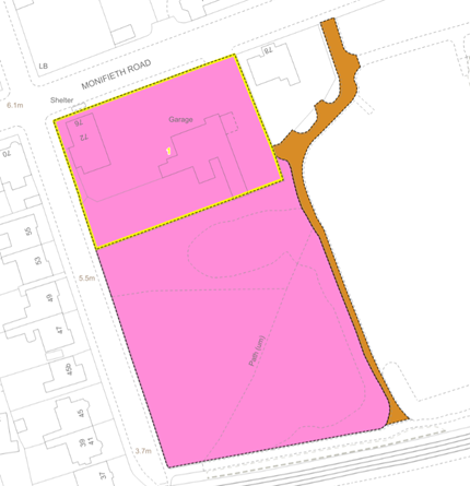
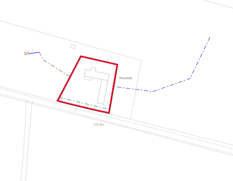
The most common reference you are likely to see on a cadastral unit is the red edge. Figure 1 shows the extent of registered land or in the case of a flatted property, it will define the tenement steading cadastral unit that represent the tenement including land next to it.
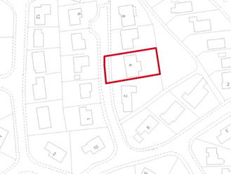
The red edging on a title plan shows you the registered land. It often follows boundary features shown on the Ordnance Survey (OS) map such as:
- walls
- hedges
- fences
Even though a legal boundary follows these OS features, it might not be obvious exactly where the legal boundary is. For example, it might run through the middle of a hedge or to one side of it.
When we prepare a title plan, we try to show the legal boundaries as accurately as we can. However, we are limited by the scale and accuracy of the OS map. Sometimes the title deeds and other information we are given do not show the true position of a boundary.
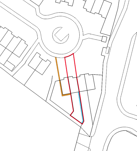
Red edging lines
Where you see red edging, the black solid or dashed line shows the feature where edging has been used. In most cases this will be to the outer edge of the red, but in some cases, this may be on the inner edge. This looks like the red edge being flipped outside of the plot of land, and was done when the red edge may have obscured small or narrow colour references within the plot. An example is shown in figure 2.
We no longer use external edges on our title plans, however registered titles with external edging will still display on title plans, until an update to the mapping of the cadastral unit is completed.
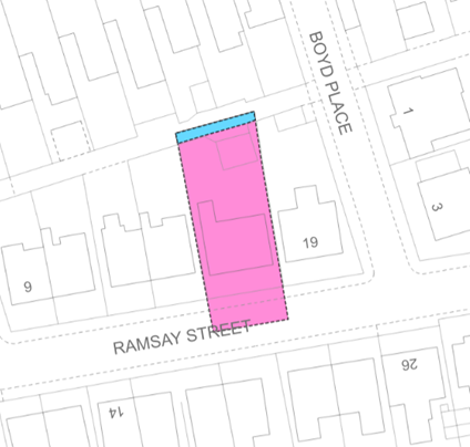
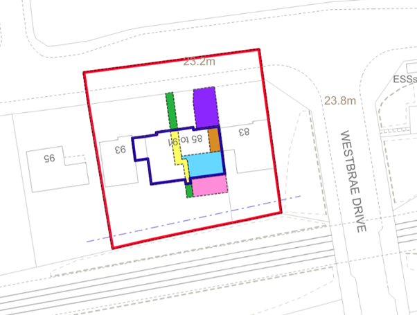
We may use tints or hatchings to represent the extent of the subjects, shown in figure 3. The exact references that are used depend on the circumstances of the specific registration.
As well as showing the position and extent of a registered plot of land, the cadastral map will reference:
- a particular part or parts of registered plot of land
- adjacent land
This is used where certain encumbrances are affected. For example, where a neighbour may have access rights or where areas of ground have been leased. To show the encumbrance on the cadastral map, a plans reference will be shown for that encumbrance. An example is shown in figure 3 and figure 4.
Coloured tints
There are common colours of tints that are used in the title plans to make sure they are easy and clear to identify. The guidelines we use are shown in the table.
| Tint colour | Tint description |
| Blue | |
| Pink | |
| Yellow | |
| Brown | |
| Mauve |
small areas such as:
|
| Red | small areas but only when no red edge has been used |
| Green |
We will try where possible to standardise the use of references, for example use:
- brown tints for servitudes in favour of subjects
- blue tints for burdens
- yellow tints for common areas
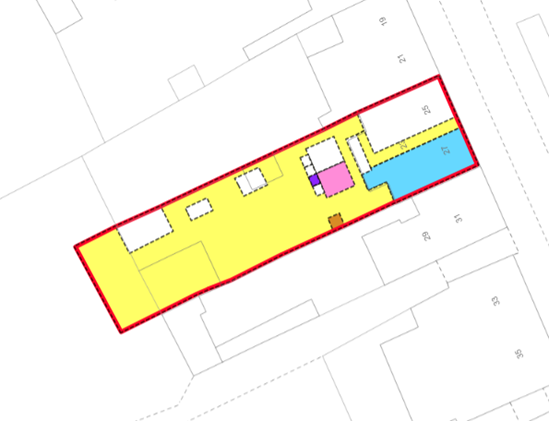
Illustrations of how different tints and edges can be used to construct cadastral units is shown in Figure 5 and Figure 6.
There are some exceptions to these guidelines, which are specific styles that are set up for certain developments that reflect Deed of Conditions (DOC) references.
Other coloured edges and numbers
We use different coloured edging and number references for large complex titles or parent titles instead of using tints.
Edging and numbering in green
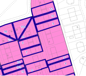
We use green edges and numbers to reference those parts of a cadastral unit where the whole right, title and interest in those parts were removed and transferred to become a separate cadastral unit. For example, when a house plot is removed from a property developer’s title. An example of this is shown in figure 7.

An alternative mapping convention is shown in figure 8, where the cadastral unit is restricted to exclude the extent of the plots removed.
Edging and numbering in blue
We use blue edges and numbers in:
- older title sheets to reference the superiority interest that used to exist in the parent title where parts of the subjects were feud. An example is shown in figure 9
- the case of tinting method, where other ways to show areas have been used. For example, to define a drying green where brown tints have already been used, you will see blue tints
There are rare instances of blue edging and numbering. For example, areas affected by DOC on certain Glasgow district council cases where additional pro indiviso land is not affected by the conditions.
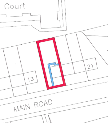
Edging and numbering in yellow
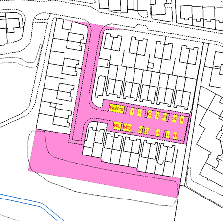
We use yellow edging and numbering to reference the part of a cadastral unit that is a registered or a recorded lease. An example is shown in figure 10.
We use brown or mauve edging and numbering to reference a part of a cadastral unit that is affected by any deed that is not a lease, for example:
- Standard Security of Part
- Discharge or Disburdenment of Part
- where multiple deeds are referred to for burdens
Edging and numbering in red
We use red edging and numbering when the area being registered, is made up of many portions. These need separate references and using other coloured edgings would be cumbersome or unclear.
Other edging and numbering
In a complex title we sometimes use an edge to free up a colour tint for another use. For example, using a blue edge instead of a blue tint for showing the solum of a building in complex titles that has multiple references. An example of this is shown in figure 11.
Numbering or lettering
We use numbers and letters for different sized areas on a cadastral map. These include:
- large areas have numbers or letters along with coloured edging
- small areas or points have a mixture of arrows, letters or numbers which are also called labels
- on a cadastral unit, individual trees within a TPO have arrows and the letter T in red
- numbering and lettering may also be used to shows areas of ground that may limited by the scale and accuracy of the OS map
Coloured broken lines
We use coloured broken lines to show:
- drainage and cables
- water and gas
- areas of ground that are limited by the scale and accuracy of the OS map
An example of a cadastral unit with various lines is shown in figure 12.
Hatching
We use hatching to increase the number of references available when mapping a complex title. There are no specific guidelines to the colour used because it is used to make the areas clearer.
A small number of historical titles have cross-hatching, which we no longer use as reference on a title plan.
A title sheet will never include a plans reference that refers to a non-coloured section of the cadastral map.
Boundary reference arrows
We no longer show boundary references descriptions on the cadastral map for new registrations in the deeds. There are many older titles registered under the previous land registration legislation that may show these as lettered with:
- blue arrows
- black arrows
Blue boundary reference arrows
These give extra information about the boundaries of a plot and were added to the title deeds to include specific information about the legal boundary relative to a physical feature such as a:
- fence
- wall
- hedge
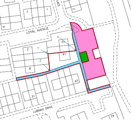
Blue arrows and letters which are also called labels, are still used on the cadastral map where the deeds show:
- burdens over specific boundaries, which is shown in figure 5
Black boundary reference arrows
These give extra information about the boundaries of a plot and were added to the title plan to include specific information about the legal boundary relative to a physical feature such as a mutual gable wall, fence or hedge. Where the arrow is:
- across a feature on the map, this indicates that the boundary is stated to be the centre line of that feature
- inside the plot and is pointing at the inside of a feature on the map, this indicates that the boundary is stated to be the inner face of that feature
- outside the plot and is pointing at the outside of a feature on the map, this indicates that the boundary is stated to be the outer face of that feature
Visualisation of the cadastral map
The cadastral map shows the total registered geospatial data, except for supplementary data in individual title sheets. For complicated titles, showing all this information on the cadastral map can be difficult.
For complicated titles, where the volume of references, including the subjects or individual references are unclear and hard to identify, references may be transferred onto additional cadastral map views. These are effectively separate layers of the cadastral map which are shown on separate plans documents from the title plan.
We use a sequential number form which is the title number then a dash and a number. For example, MID1-1. Supplementary data can also be presented in this same way and is shown within the title sheet.